Evaluation of Streamflow Depletion Related to Groundwater Withdrawal, Humboldt River Basin
Models
Three transient, regional-scale flow models will be developed and documented. The two models being developed by USGS (middle and lower HRB) will follow similar construction, design, and calibration approach and will be constructed using MODFLOW-NWT. Model approach includes:
- Determining/refining hydraulic properties through model calibration and aquifer test analysis.
- Reformulating calibrated models to answer questions and address objectives.
- Developing reference scenario where groundwater is not pumped.
- Developing streamflow depletion maps.
- Evaluating mine dewatering for the middle Humboldt River Basin model.
Click on image for larger view.
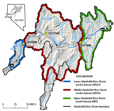
Model Domain Boundaries Within the Humboldt River Basin
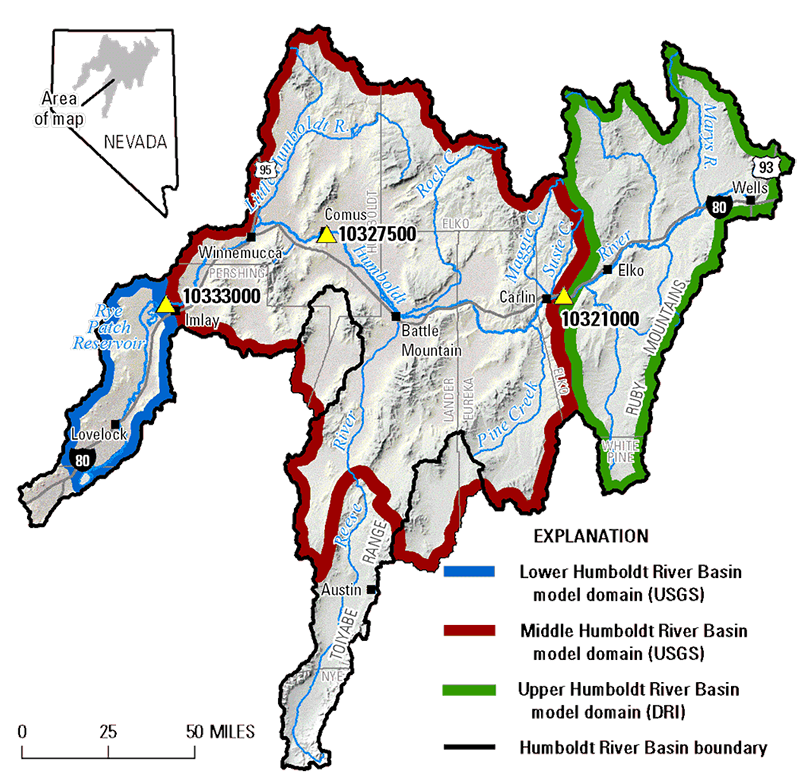
Middle Humboldt River Basin
The existing Middle HRB flow model will be revised and recalibrated. Flow will come into the model from the Upper HRB model at USGS gaging station Humboldt River near Carlin (site id 10321000).
Drainage Area: 11,160 square miles
Grid Cells: 36,623 active grid cells that are 2,000 ft square (about 92 acres per cell)
Boundary: Follows the Humboldt River Basin from upstream of the Carlin streamgage downstream to the Imlay streamgage. The boundary also includes Grass Valley (Hydrographic Area 138) and Buffalo Valley (Hydrographic Area 131)
Major Drainages: Pine Creek, Susie Creek, Maggie Creek, Martin Creek, Rock Creek, Little Humboldt River, the lower parts of the Reese River Valley, and the upper part of the Little Humboldt River drainage
Hydrogeologic Framework
Will be discretized using a uniform grid and divided into 4 hydrologic model layers
- Model Layer 1
-
- Upper-most model layer
- Represents the Humboldt River flood plain
- Includes evapotranspiration processes
- Is variable thickness
- Model layer 2
-
- Represents basin-fill aquifer system from which irrigation withdrawals occur
- Where layer 2 extends to land surface (i.e., in areas where layer 1 is inactive), evapotranspiration will be simulated
- Model Layer 3
-
- Represents consolidated rock
- Includes hydrogeologic units from which mine dewatering takes place
- Model Layer 4
-
- Represents consolidated rock also
- Will be used as a groundwater storage reservoir
Pit Lakes
Formation of pit lakes will be represented in the middle HRB model for the mine dewatering operations that have or potentially will result in pit lake formation when mine dewatering is stopped.
Pit lakes will be simulated using the MODFLOW Lake package and will occur in the model layer 2 if pit lake occurs in basin fill or from layer 3 if pit lake is formed in consolidated rock unit. Simulation of filling of pit lakes will result from groundwater inflow to lakes from adjacent aquifer material as well as from direct precipitation and any surface runoff contributions that are specified.
The Lake package simulates lake evaporation from and precipitation onto lake surface area that is related to simulated lake depth. Lake evaporation and precipitation rates are specified and will be based on existing estimates of open water evaporation and precipitation rates.
Lower Humboldt River Basin
New model will be built and calibrated.
Drainage Area: 1,160 square miles
Grid Cells: 8,398 active grid cells that are 2,000 ft square (about 92 acres per cell)
Boundary: Outlines the basin boundary from the Imlay streamgage to the Humboldt Dike
Hydrogeologic Framework
Will be discretized using a uniform grid and divided into 2-3 hydrologic model layers.
- Model Layer 1
-
- Upper-most model layer
- Represents the Humboldt River flood plain
- Includes evapotranspiration processes
- Is variable thickness
- Model layer 2
-
- Represents basin-fill aquifer system from which irrigation withdrawals occur
- Where layer 2 extends to land surface (i.e., in areas where layer 1 is inactive), evapotranspiration will be simulated
- Model Layer 3
-
- Represents the basin-fill aquifer system in places where its saturated thickness is greater than the extent of layer 2
- Will not simulate groundwater flow in consolidated rock units as there is no mine dewatering occurring within this model domain and it is assumed groundwater flow is negligible in comparison to the basin-fill aquifer