U.S. Geological Survey — U.S. Department of Energy Cooperative Studies and Groundwater Monitoring in Nevada
Environmental Management-Nevada Program/Underground Test Area
Nuclear testing at the Nevada National Security Sites (NNSS) has created potential environmental hazards. The U.S. Department of Energy (DOE), Environmental Management-Nevada (EM-NV) Program is concerned about these hazards and is committed to comply with existing environmental laws and regulations. EM-NV is tasked with implementing corrective actions for inactive contaminated sites and facilities in Nevada where nuclear testing occurred. In this regard, DOE established, and EM-NV manages, the Underground Test Area (UGTA) Activity. The UGTA Activity goals are to identify risks where radiological contamination may exist in groundwater because of underground nuclear tests, predict the movement of potentially contaminated groundwater, and define contaminant boundaries or extent of migration of radionuclides released during nuclear testing.
The U.S. Geological Survey (USGS) provides hydrologic expertise and technical guidance to EM-NV in support of the UGTA Activity, primarily on tasks related to the characterization of groundwater flow systems. Principal USGS objectives for this program are to:
- Collect, compile, store, and report hydrologic data used in determining the local and regional hydrogeologic conditions at and in the vicinity of the NNSS.
- Support the USGS Core Library and Data Center (CLDC), which is a repository for hydrologic, geologic, and geophysical data and materials collected in support of environmental programs at the NNSS. This material includes more than two million linear feet of core and cuttings collected mostly from the NNSS.
- Preserve high-resolution digital photographs of rock samples (core and cuttings) stored at the CLDC.
- Provide hydrologic field services including video logging of wells and boreholes, and calibration of measuring equipment, as requested.
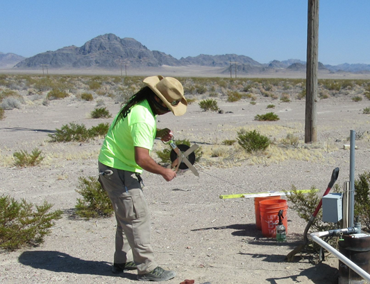
Hydrologist measuring depth to water with a hand-held steel tape in well Amargosa Desert 4b.
For More Information
Jeff Sanders
[email protected]
U.S. Geological Survey,
Nevada Water Science Center
500 Date Street
Boulder City, NV 89005
Phone: 702-294-6052